Dora Kreković / September 18, 2025
Digital technologies are increasingly finding their way into agriculture. Farmers can now use networks of sensors to track conditions such as temperature, soil moisture, and rainfall. These Internet of Things (IoT) devices provide continuous measurements that support more informed decisions about planting, irrigation, and harvesting.
Alongside the benefits comes a practical issue, managing the large amounts of data sensors create.
Every sensor can generate hundreds or thousands of readings per day. When dozens of sensors are deployed across large farms, the result is a flood of data that needs to be transmitted, stored, and processed. Rural farms often struggle with limited connectivity, and battery-powered devices can’t afford to waste energy on unnecessary transmissions.
Much of this data is also repetitive. For example, if the air temperature remains at 25 °C for several hours, each identical reading is still sent to the cloud. In effect, the system keeps transmitting the same information again and again.
Clearly, there must be a smarter way.
The Idea: Predict, Then Transmit
Our research [1] explored a lightweight approach to reduce redundant data transmissions: instead of sending every sensor reading, devices predict the next measurement and only transmit data when the actual value differs significantly from the prediction.
For example, if a smartwatch can estimate that your heart rate will remain around 70 beats per minute while you are resting, there is little value in sending the same reading repeatedly. A notification is only needed when something changes noticeably, such as the heart rate rising to 95.
Applied to farming, this means:
- Less wasted bandwidth.
- Longer battery life for sensors.
- Farmers still get alerted when something important changes.
This prediction is performed directly at the network edge, while an identical model runs in the cloud to ensure that complete data remains available for management, analysis, and decision-making. Here’s how it works:
- The device uses recent history to forecast the next value, such as the upcoming temperature.
- When the new reading comes in, the sensor checks: is it close enough to the prediction?
- If yes → no need to transmit; the model already “knew” this.
- If no → transmit the real reading, since something important has changed.
This way, sensors avoid wasting energy and bandwidth on redundant information while still alerting the system to meaningful changes.
In other words, sensors communicate only when the new reading adds useful information.
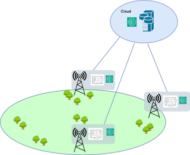
Figure 1. System Overview: Local Edge Prediction with Cloud Synchronization
Deployment Scenarios
Agricultural environments vary widely in terms of available data, connectivity, and infrastructure. To evaluate the practicality and adaptability of our approach, we considered several scenarios. Each scenario reflects a common real-world condition, ranging from farms with established sensor networks to regions with limited or no connectivity.
For this evaluation, we relied on two complementary datasets. The first was a network of agrometeorological stations in Croatia [2], which measure air temperature every 10 minutes and provide ground-level validation under realistic conditions.
At the same time, we recognized that many farms do not have years of local sensor logs to train predictive models. To address this, we turned to Copernicus ERA5-Land [3], a publicly available satellite dataset that offers high-resolution weather and environmental data across Europe. By training our models on satellite-derived data, we could generate predictors even for locations with no historical on-the-ground measurements.
Together, these two sources made the system both accurate and scalable: ground stations allowed us to test performance in real deployments, while satellite data enabled the creation of ready-to-use models for farms that lack long-term local records.
Scenario 1: In-Situ Training and Local Inference
The most straightforward approach is to train the AI model on data collected at the same location where it will be deployed.
- Pros: The model is highly tailored to local conditions.
- Cons: You need plenty of historical data first, which isn’t always available in new or remote farms.
When tested in Croatia, models trained and used at the same location were very accurate, while also cutting transmission by more than 94% at a more relaxed, 1.0 °C threshold. This proves that even simple farms can benefit from smarter edge intelligence.
Scenario 2: Cross-Site Inference
Of course, not every farm (or location) has enough data to train its own model. A natural next step is to ask: can a model trained at one location be used somewhere else?
This is the cross-site inference scenario. We trained models at one location (say, inland Croatia) and deployed them at another (like the coast). Despite differences in climate, the models still worked surprisingly well, especially when using a slightly relaxed error tolerance. In our tests, data transmissions were reduced by more than 96% at a 1.0 °C threshold, while still maintaining accuracy above 92%. Even at the stricter 0.5 °C threshold, reductions remained in the range of 82–87%.
This suggests that a model trained in one location can still perform well in other regions, provided some flexibility in error tolerance. In practice, this means that a single well-prepared model can support multiple farms, reducing the need to collect and maintain large amounts of training data at each site. Such generalization is particularly valuable for scaling predictive edge AI, as it lowers deployment costs and speeds up adoption in areas with limited data availability.
Scenario 3: Satellite-to-Ground Transfer
One of the main challenges in smart agriculture arises when a farm lacks any historical data. To train a predictive model, you would normally rely on past sensor readings that capture local conditions and parameters. But in many cases, especially at new sites, such records simply do not exist, not even from nearby locations.
To address this, we explored the use of satellite data. By relying on Copernicus ERA5-Land, we were able to build models tailored to local environmental conditions without requiring prior ground-based measurements. This approach makes the system scalable, since predictive models can be deployed from the very beginning, even in areas with no history of local sensing.
- Farmers could start with a pre-trained model.
- Sensors only needed to send data when it deviated from predictions.
- No long “data collection” period was required before the system became useful.
On average, satellite-trained models reduced transmissions by 75% at a 0.5 °C threshold and by 93% at a 1.0 °C threshold, demonstrating that predictive edge AI can be deployed effectively even without local historical data.
Across all deployment scenarios, predictive edge AI consistently achieved >92% reduction at a 1.0 °C threshold, demonstrating strong scalability even in farms without local historical data, as shown in Figure 2.
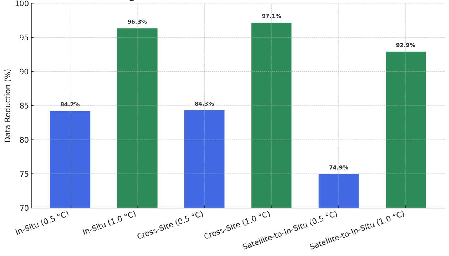
Figure 2. Average Data Reduction Across Deployment Scenarios
Why This Matters for Agriculture
Smart farming is not only about collecting more data, but about doing so in a way that is efficient and practical.
- Energy efficiency: Fewer transmissions mean longer battery life, reducing the need for costly maintenance in the field.
- Connectivity resilience: Farms with poor or intermittent Internet connections can still benefit from reliable monitoring.
- Scalability: Farmers can deploy more sensors without overwhelming networks or budgets.
- Climate adaptation: With predictive monitoring, farmers can better respond to sudden changes in weather or soil conditions.
This dual setup combines the efficiency of edge-based filtering with the reliability of cloud analytics, ensuring that farmers save energy and bandwidth while still retaining access to the complete dataset for management and long-term analysis.
Ultimately, this approach brings us closer to climate-smart, data-efficient agriculture, a future where technology empowers farmers without burdening them with complexity.
For farmers, this technology means more reliable insights with fewer technical headaches and for the IoT world, it’s a step toward smarter, more efficient systems that don’t rely on constant cloud connections. As agriculture faces climate challenges and a growing need for efficiency, solutions like predictive edge computing could be key to ensuring food security, without overwhelming our digital infrastructure.
Looking Ahead
While our results are promising, there’s still room to grow. Future work will focus on:
- Shrinking models further so they can run on ultra-low-power chips.
- Adapting on the fly, allowing sensors to “learn” from changing local conditions.
- Expanding beyond temperature, adding soil moisture, rainfall, and other variables for a richer picture.
- Validating over the long term, to understand how systems perform through seasons and years.
What’s clear already is that predictive edge AI has the potential to transform farming. By combining satellites, smart algorithms, and tiny devices in the field, we can build a system that is not only intelligent but also efficient and sustainable.
More details on the technical implementation, results, and evaluation scenarios can be found in our article, “Edge-Based Predictive Data Reduction for Smart Agriculture: A Lightweight Approach to Efficient IoT Communication,” available on arXiv (link) and accepted for presentation at the AIOT 2025 Conference in Osaka.
References
2. Kreković, D.; Galić, V.; Tržec, K.; Podnar Žarko, I.; Kušek, M. Comparing Remote and Proximal Sensing of Agrometeorological Parameters across Different Agricultural Regions in Croatia: A Case Study Using ERA5-Land, Agri4Cast, and In Situ Stations during the Period 2019–2021. Remote Sens. 2024, 16, 641. https://doi.org/10.3390/rs16040641